Overview
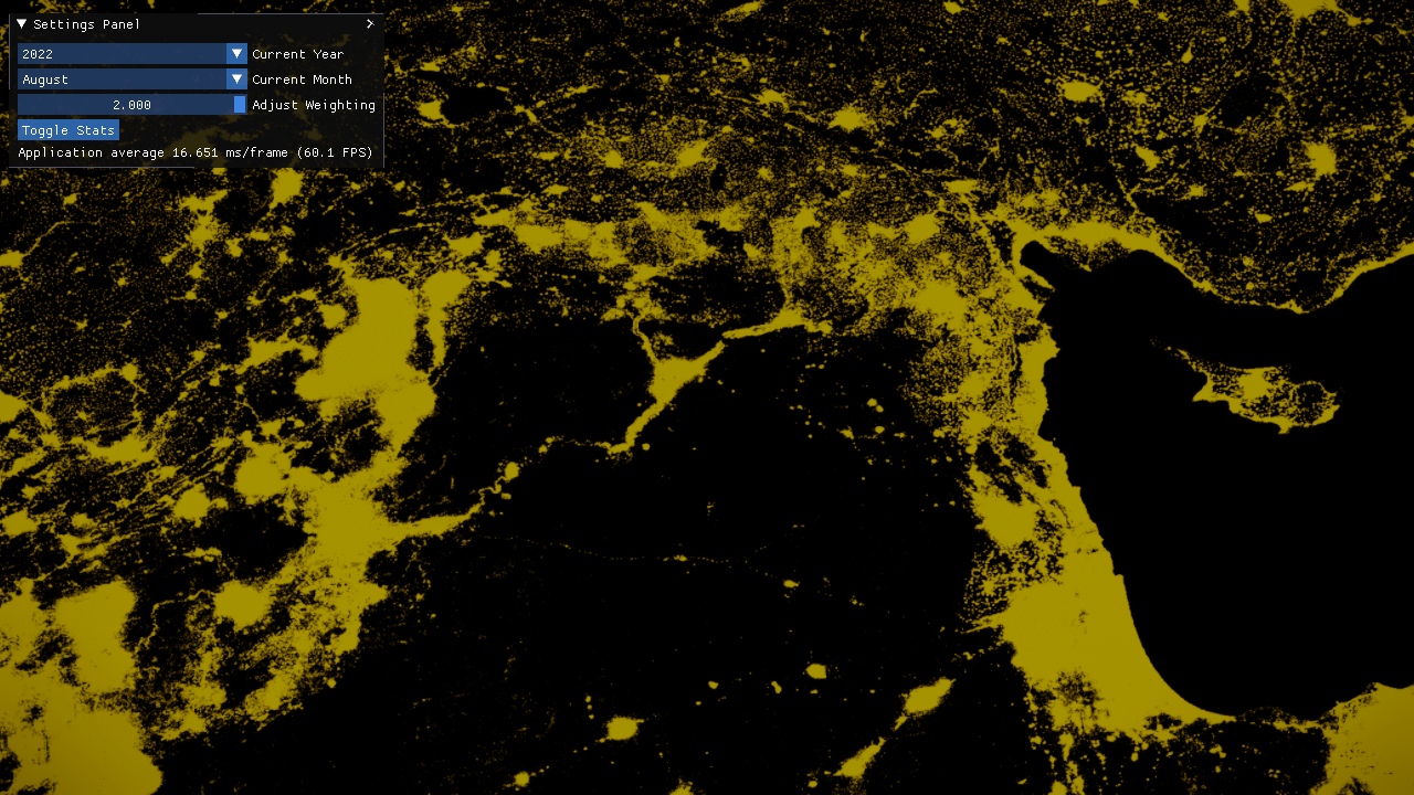
The XII Geospatial Platform enables interactive exploration of economic activity in Syria by rendering night-time satellite light captures at 4K resolution. Users can scrub through months and years, blend temporal data, and export high-res screenshots, all at real-time frame rates thanks to a GPU-optimized format and custom game engine core.
Motivation
Night lights derived from satellite imagery have become a trusted proxy for measuring local economic dynamics, urban growth, and infrastructure development. Yet existing GIS tools either lack real-time interactivity or force repeated on-the-fly recompression. By pre-compiling light captures into a GPU-friendly texture format and leveraging our in-house engine, the platform lets analysts fluidly compare temporal snapshots without I/O stalls or frame drops.
Key Features
- Pre-compiled 4K tiles in a custom GPU-optimized data format.
- Temporal blending slider (between previous and next month).
- Interactive camera controls: pan, zoom, rotate, and tilt.
- On-screen statistics: FPS, memory usage, and profiling data.
- Export high-resolution screenshots via F12.
- In-engine debug console (F2) with auto-complete commands.
- Supports D3D11 today; experimental D3D12 and Vulkan backends in development.
Architecture
- Data Ingestion
- Offline tool converts raw GeoTIFFs into tiled textures.
- Metadata database indexes region, year, month.
- Rendering Pipeline
- Custom C++/TypeScript engine orchestrates scene graph.
- Deferred shading for terrain base, additive pass for night lights.
- Shader modules implement intensity scaling and color mapping.
- UI & Controls
- TypeScript-driven UI panel for date selection and blending.
- IPC channel to external profilers and scripting consoles.
- Resource Management
- Streaming loader fetches only visible tiles.
- LRU cache for GPU textures to maintain 60+ FPS.
Data Sources
- VIIRS Nighttime Lights (Volcanic Radiance).
- DMSP-OLS Historical Night Lights.
- Custom preprocessing to normalize radiance values per tile.
Usage Guide
git clone https://github.com/TheophilusE/XIIGeospatialPlatform.git
cd XIIGeospatialPlatform/Binaries/GeospatialPlatform
./Launch\ MainScene.bat
- Use the settings panel to choose year/month.
- Adjust weighting slider to blend temporally between captures.
- F12: capture screenshot.
- F2: open debug console (tab-autocomplete).
- F5: toggle FPS counter.
Note: currently supported on Windows only; experimental D3D12 and Vulkan builds exist but lack full feature parity and unit tests.
Performance Benchmarks
| Resolution | Average FPS | GPU Memory Footprint |
|---|---|---|
| 1920×1080 | 120 FPS | 1.5 GB |
| 2560×1440 | 90 FPS | 2.2 GB |
| 3840×2160 | 60 FPS | 4.8 GB |
| Tiles Streamed | Frame Drops (<1 ms stall) |
|---|---|
| 16 | 0 |
| 32 | 2 per 1,000 frames |
| 64 | 5 per 1,000 frames |
Testing & Quality
- Over 100 unit tests (C++ engine + TypeScript UI).
- Fuzz testing for tile loader and blending logic.
- Continuous integration on Windows with graphics regression checks.
- Profiling harness to catch GPU memory leaks.
Installation
No external dependencies beyond DirectX 11 runtime (or Vulkan SDK for experimental builds).
- Clone the repo.
- Run
./Launch MainScene.batin theBinaries/GeospatialPlatformfolder. - Allow firewall access for IPC and profiling channels.
Contribution Guidelines
- Fork the repo and create feature branches.
- Adhere to the code style (see
.clang-formatandtslint.json). - Write or update unit tests for any new feature.
- Open pull requests against
Developmentbranch. - Expect feedback within 48 hours.
Future Roadmap
- Publish on Windows Store and Steam for easy installation.
- Complete and stabilize D3D12/Vulkan renderers.
- Add support for global datasets beyond Syria.
- Integrate time-series charting alongside map view.
- Expose plugin API for custom shaders and analysis scripts.
License
This project is released under the MIT License. See LICENSE for full terms.